

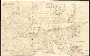
A new and correct chart of the Channel between England and France with considerable improvements not extant in any draughts hitherto publish'd shewing the sands, shoals, depths of water and anchorage, with ye flowing of ye tydes, and setting of the current; as observed by the learned Dr. Halley. Sold by Mount & Page on Tower Hill, London. Inset: A correct draught of Plymouth Sound, Cattwater and Ham Owse; A new draught of the Isle of Wight
Collins, Captain Greenvile (or Greenville)
A�o de publicaci�n: 1774
Mapa
Condici�n: Good
Librer�a: Antiqua Print Gallery, London, Reino Unido
Calificaci�n del vendedor: 4 de 5 estrellas
![]()
Vendedor de AbeBooks desde 14 de enero de 2022
Comprar usado
Precio:
EUR 840,87
Convertir moneda
Gastos de env�o:
EUR 8,75
De Reino Unido a Estados Unidos de America
Destinos, gastos y plazos de env�o
Cantidad disponible: 1 disponibles
A�adir al carrito