Descripci�n
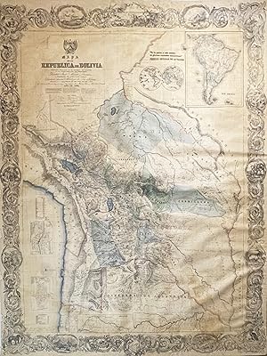
Lithographed map with full original hand colour, printed on 4 sheets and contemporarly joined and mounted upon old linen, rolled (slightly age-toned, light brown stain in the lower right part, minor scratches and folds on the surface, tiny pin holes in the margins), 182 x 140 cm (71.6 x 55.1 x inches). Very rare Juan Ondarza s large and highly detailed wall map of Bolivia, the first proper survey of the republic and one of the great monuments of the 19th Century cartography of Latin America, published by J.H. Colton in New York; at the centre of an entertaining, yet bizarre, story of intrepid Andean surveying, patriotic pride, financial scandal and earthquakes! - This spectacular wall map of Bolivia is one of the great landmarks of the cartography of Latin America. It represents the first accurate general survey of Bolivia and is by far the largest and most detailed map of the republic produced during the 19th Century. Interestingly, it also shows Bolivia with its territory at its maximum historical extent, before it ceded vast amounts of its landmass following wars and, in some cases, 'bizarre diplomatic incidents involving its neighbours. Printed by the leading American map publisher, Joseph Hutchins Colton, it is also the first national map produced in the United States at the behest of a foreign government (a practice that would become common later in the century). The story behind the map s production is a carnival of extraordinary events. It involves a dangerous 11 year-long reconnaissance of a one of the world s most rugged landscapes, the hindrance of the dissemination of the map by military coups and earthquakes, and a process that resulted in the bankruptcy of America s leading mapmaker. Bolivia was then a vast, geographically diverse and, in many parts, inhospitable land that spanned from the peaks of the Andes to the coastal Atacama Desert (the world s driest region) to the plateau of the Gran Chaco to the Amazonian Rainforest. The dramatic topography is vibrantly expressed through the use of hachures and shading, and the landscape is replete with details as to the locations of cities, towns, mines, rivers, roads, post offices, mountain ridges and other features. The republic s various departments are distinguished in full regional colours typical of the productions of the Colton firm, while the great Andean lakes of Titicaca and Poop� and the shores of the Pacific are coloured in brilliant blue. In the lower left corner of the map are detailed insets of La Paz (the main commercial centre of Bolivia), labeling 18 key sites and Sucre (the national capital), labeling 27 sites, along with a table noting the heights of the nation s major Andean peaks. In the upper right, the map features a large inset of South America, placing Bolivia within its greater geographical context. The title, in the upper left, is surmounted by the national coat of arms, while the map features an elegant border of spiraling acanthus scrolls, containing roundels featuring picturesque Bolivian scenes. The map is signed by Juan Ondarza Lara and his assistant Juan Mariano Mujia, in the lower left. The Bolivia portrayed on the map is far more expansive than it is in its current form. While the centre of the country as shown here, remains Bolivia today, the extremities on north, southeast and southwest are today all part of neighbouring countries. The northern Amazonian portion, along with a sliver of the Mato Grosso in the east, was ceded to Brazil in parts, in 1867 and 1903. The Coastal Atacama region was lost to Chile, following the War of the Pacific (1879-84) and the Gran Chaco region in the southeast was lost to Paraguay following the Chaco War (1932-35). SEE OUR WEB PAGE FOR A LONGER DESCRIPTION. N� de ref. del art�culo 69734
Contactar al vendedor
Denunciar este art�culo


