Descripci�n
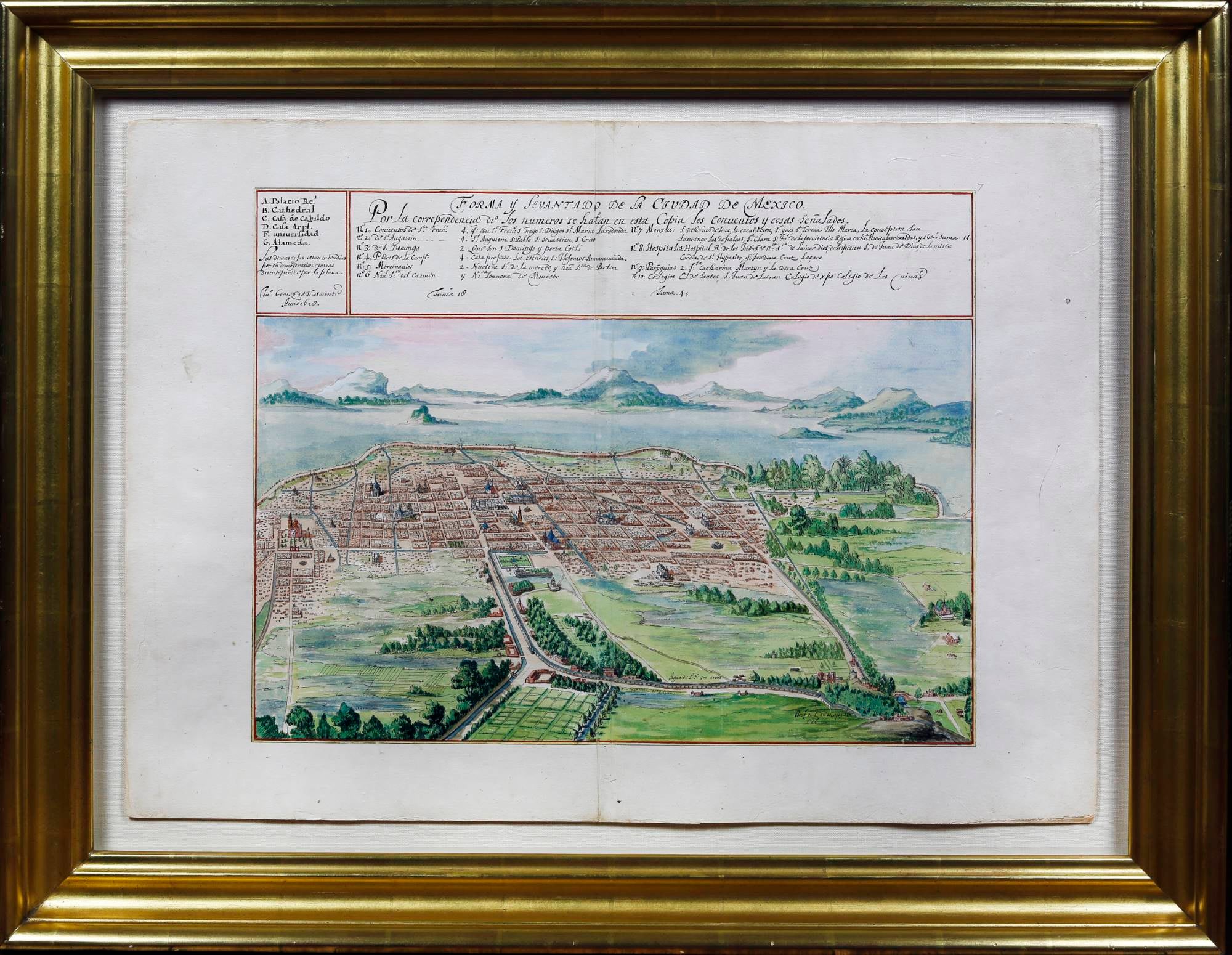
AN EPOCHAL MANUSCRIPT WATERCOLOR VIEW --THE FIRST CHOROGRAPHIC REPRESENTATION OF MEXICO CITY -- THE ONLY COPY OUTSIDE INSTITUTIONAL COLLECTIONS. "Anno 1628" [Amsterdam, ca. 1665.] Two sheets joined (20 1/2" x 29"; 16" x 21 1/4" to the neat line). Watermark: a shield with a bear, coronetted (i.e., Bern, Switzerland). In 1521 the kingdom of New Spain was founded. Its capital was the former capital of the Aztec Empire, Tenochtitlan, renamed to Mexico City. Keeping the old capital was convenient for a variety of reasons, but it was not without challenges: since it was ringed by lakes at the bottom of a valley, the city was prone to seasonal flooding. For well over a century attempts were made to mitigate this flooding; this view of the city was made as part of that process. Juan G�mez de Trasmonte (d. 1647) was master builder and one of the architects of the Metropolitan Cathedral in Mexico City. After the failed attempts of Enrico Mart�nez in 1629, there was a massive and catastrophic flood that paused construction of the cathedral (it can be seen partly-constructed just Norh of the Plaza Mayor (Z�calo)), and Trasmonte superintended various projects to manage water in the city. Illustrating the present item, Priscilla Connolly and Roberto Mayer argue that the Trasmonte view "clearly had persuasive intentions," viz. he shows "the lakes not as an insuperable problem that have to be drained, but as a natural feature that the city can enjoy if afforded sufficient protection" (op. cit. 55, 57). The iconography of the map, showing the lake as placid and its shores verdant, is crucial to Trasmonte's proposal: implementing a series of dykes and canals in order to regulate the flow of water. Trasmonte's view is here present in a watercolor copy by the Dutch artist and cartographer Johannes Vingboons (1616/17-1670), who from 1640 was employed by the cartographic publisher Joan Blaeu. How did he come to possess the original in Amsterdam? Connolly-Mayer proposes a swashbuckling tale involving the capture of the Spanish Flota on 8 September 1628 by the Dutch privateer Piet Hein (ibid., 59-60), who worked for the Dutch West India Company. Vingboons's father, David Vinckboons, was commissioned to paint oils (destroyed in WWII). Six of Vingboons's copies of his father's copies of the view of Mexico City are known: in the Vatican Library's "Christina atlas", among the "Carte di Castello" at the Biblioteca Medicea Laurenziana in Florence, in the "Blaeu-van der Hem" atlas in the �sB Vienna (authorship disputed), two unfinished versions at the BnF (authorship disputed) and the present item. The present item was, we believe, part of the "Van Keulen/Bom atlas," which belonged to descendants of the great cartographic publishing firm of Van Keulen, and was broken and disbursed in 1885. The so-called "secret atlas" of mostly unpublished maps for the VOC was a trove of valuable cartographic data; very faint grid-lines present on our copy indicate that some attempt was made to prepare it for publication, though it never was. This belief is strengthened by the manuscript "7" at the upper right-hand corner of the map, which matches numeration in other maps from the Van Keulen/Bom atlas. Connolly-Mayer explain that one of the authors was contacted by a Mexican collector with the views (ours is their color plate 6), who explained that his father had bought them in Antwerp shortly after 1946 (ibid., 49). It is difficult to overstate the importance of such a view historically and artistically. Vingboons's manuscript work was sought by royalty (Queen Christina Alexandra of Sweden, Cosimo III de' Medici) as the other known copies attest. Even into the Dutch golden age of mapmaking, the sensitivity and nuance of watercolor was prized above the repetitive accuracy of engraving. Connolly, Priscilla and Roberto Mayer. "Vingboons, Trasmonte and Boot: European Cartography of Mexican Cities in the Early Seventeenth Century." Imago Mundi 61, no. 1 (2009) 47-66. N� de ref. del art�culo 6JLR0156
Contactar al vendedor
Denunciar este art�culo
